Lucile Sautot PhD thesis
 Modeling relationships between bird species and the environment along the Loire River, and designing of a bio-indication index, with business intelligence tools
Defended on the 9th October 2015
Funding: Ministry of Agriculture, FCPR project (100%)
Supervisor: Bruno Faivre
Started in November 2012
Abstract
In the context of the research works carried out for the Biogeosciences Laboratory of the University of Burgundy, a bird census program is performed along rivers since 1990 by Pr. Bernard Frochot and Pr. Bruno Faivre. The aim of this program is studying the bird communities distribution along the upstream-downstream gradient and the relationships between bird assembly and landscape at several spatial scales. These works have three goals:
-
First, this study provides an understanding of relationships between species and environment and particularly of the landscape impact (habitat diversity, land-use, …) on the species distribution along rivers.
-
Secondly, the monitoring of bird communities aims to assess the temporal changes of bird communities on pluriannual time interval and to explore the local and global factors, which can explain these changes.
-
Finally, this project aims to design bio-indication tools base on this spatial temporal analysis of relationships between bird communities and environment.
 Since 1990, this program named STORI (Suivi Temporel des Oiseaux nicheurs en Rivière: Temporal Monitoring of Nesting Birds in River Valley) has collected numerous data about riparian bird communities, particularly on two rivers considered as preferred models : the Loire River and the Allier River (France). The collected data set contains:
-
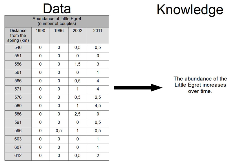
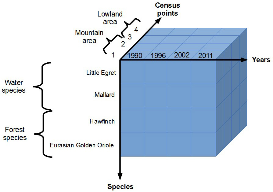
The qualitative and quantitative description of nesting bird communities (170 species approximately) along the Loire River and the Allier River. This description is provided on 291 census points by the Punctual Abundance Index (PAI) method.
-
The environmental data for each census point: 23 variables describe the near and distant environment. The variables are recorded on the field or come from maps or several environmental databases.
-
35 variables come from analysis of satellite images. These variables represent the landscape mosaic. Some variables measure habitat fragmentation, heterogeneity or connectivity between structural elements of the landscape.
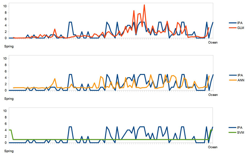
Preliminary results present a spatial and temporal evolution of the distribution and the abundance of some species. But the analysis merits to be improved and increased, particularly if we want analyze the impact of anthropization on bird populations. Now, two problems must be solved to continue the analysis: on the one hand, new data are necessary to improve the analysis of observed variations in the bird communities, and on the other hand, the volume and the heterogeneity of the data make difficult the processing of data with classical data management tools and classical statistical tools. For example, we want analyze geographical data, which need special processing.
 To satisfy these needs, the business intelligence tools are suitable because they are able to integrate, process and explore data from numerous and heterogeneous origins. These tools contain concepts from data mining, machine learning, databases, data warehouses and information systems.
In this context, the general goal of this PhD is to create a tool, that process these data and find the factors, which explain the observed variations in bird populations along the Loire River and the Allier River over time and space. More precisely, we want broaden the analysis of relationships between environment and bird communities with optimization of quantitative and statistical methods and with integration of new environmental data. An other important point is the analysis of temporal dimension, that we observe through the changes in communities and environment. Ultimately, our ambition is to build a tool, which combine several spatial descriptions of census points at several scales. For example, various databases will be integrated, thanks to our partners:
-
An information system about the evolution of the Loire riverbed (SIEL: Système d’Information sur l’Evolution de la Loire), which provides a map of a part of the river (from Roannes to Nantes, France) between the dikes.
-
MAGDALENA, the database of the French Water Agencies, which contains data about water quality and town and country planning along the river.
-
The database SYRAH, which describes all the french rivers (width, depth, slope, …)
This PhD includes the search and the potential integration of other relevant databases.
Moreover, several summarized index complete the environmental and ornithological descriptions. Among these index, an anthropophily index enables the estimation of species ability to tolerate the anthropic space (agriculture, urbanism, dam, …). A specialization index (ability to adapt to various habitat) and a thermic index (average temperature on the species distribution area).
Keywords
business intelligence, data warehouse, OLAP, data mining, birds, modeling, bio-indication
Comittee
Kokou Yetongnon, LE2I Laboratoire électronique, informatique et image, UMR CNRS 6306, université de Bourgogne
Jean Secondi, GECCO Groupe écologie et conservations des vertébrés, université d’Angers
Francis Aubert, CESAER Centre d’économie et de sociologie appliquées à l’agriculture et aux espaces ruraux, UMR INRA – AgroSup Dijon
- extrait:
- lien_externe:
- kc_data:
- a:8:{i:0;s:0:"";s:4:"mode";s:0:"";s:3:"css";s:0:"";s:9:"max_width";s:0:"";s:7:"classes";s:0:"";s:9:"thumbnail";s:0:"";s:9:"collapsed";s:0:"";s:9:"optimized";s:0:"";}
- kc_raw_content:
- Modeling relationships between bird species and the environment along the Loire River, and designing of a bio-indication index, with business intelligence tools
Defended on the 9th October 2015
Funding: Ministry of Agriculture, FCPR project (100%)
Supervisor: Bruno Faivre
Started in November 2012
Abstract
In the context of the research works carried out for the Biogeosciences Laboratory of the University of Burgundy, a bird census program is performed along rivers since 1990 by Pr. Bernard Frochot and Pr. Bruno Faivre. The aim of this program is studying the bird communities distribution along the upstream-downstream gradient and the relationships between bird assembly and landscape at several spatial scales. These works have three goals:
-
First, this study provides an understanding of relationships between species and environment and particularly of the landscape impact (habitat diversity, land-use, …) on the species distribution along rivers.
-
Secondly, the monitoring of bird communities aims to assess the temporal changes of bird communities on pluriannual time interval and to explore the local and global factors, which can explain these changes.
-
Finally, this project aims to design bio-indication tools base on this spatial temporal analysis of relationships between bird communities and environment.
 Since 1990, this program named STORI (Suivi Temporel des Oiseaux nicheurs en Rivière: Temporal Monitoring of Nesting Birds in River Valley) has collected numerous data about riparian bird communities, particularly on two rivers considered as preferred models : the Loire River and the Allier River (France). The collected data set contains:
-
The qualitative and quantitative description of nesting bird communities (170 species approximately) along the Loire River and the Allier River. This description is provided on 291 census points by the Punctual Abundance Index (PAI) method.
-
The environmental data for each census point: 23 variables describe the near and distant environment. The variables are recorded on the field or come from maps or several environmental databases.
-
35 variables come from analysis of satellite images. These variables represent the landscape mosaic. Some variables measure habitat fragmentation, heterogeneity or connectivity between structural elements of the landscape.
Preliminary results present a spatial and temporal evolution of the distribution and the abundance of some species. But the analysis merits to be improved and increased, particularly if we want analyze the impact of anthropization on bird populations. Now, two problems must be solved to continue the analysis: on the one hand, new data are necessary to improve the analysis of observed variations in the bird communities, and on the other hand, the volume and the heterogeneity of the data make difficult the processing of data with classical data management tools and classical statistical tools. For example, we want analyze geographical data, which need special processing.
 To satisfy these needs, the business intelligence tools are suitable because they are able to integrate, process and explore data from numerous and heterogeneous origins. These tools contain concepts from data mining, machine learning, databases, data warehouses and information systems.
In this context, the general goal of this PhD is to create a tool, that process these data and find the factors, which explain the observed variations in bird populations along the Loire River and the Allier River over time and space. More precisely, we want broaden the analysis of relationships between environment and bird communities with optimization of quantitative and statistical methods and with integration of new environmental data. An other important point is the analysis of temporal dimension, that we observe through the changes in communities and environment. Ultimately, our ambition is to build a tool, which combine several spatial descriptions of census points at several scales. For example, various databases will be integrated, thanks to our partners:
-
An information system about the evolution of the Loire riverbed (SIEL: Système d'Information sur l'Evolution de la Loire), which provides a map of a part of the river (from Roannes to Nantes, France) between the dikes.
-
MAGDALENA, the database of the French Water Agencies, which contains data about water quality and town and country planning along the river.
-
The database SYRAH, which describes all the french rivers (width, depth, slope, …)
This PhD includes the search and the potential integration of other relevant databases.
Moreover, several summarized index complete the environmental and ornithological descriptions. Among these index, an anthropophily index enables the estimation of species ability to tolerate the anthropic space (agriculture, urbanism, dam, …). A specialization index (ability to adapt to various habitat) and a thermic index (average temperature on the species distribution area).
Keywords
business intelligence, data warehouse, OLAP, data mining, birds, modeling, bio-indication
Comittee
Kokou Yetongnon, LE2I Laboratoire électronique, informatique et image, UMR CNRS 6306, université de Bourgogne
Jean Secondi, GECCO Groupe écologie et conservations des vertébrés, université d'Angers
Francis Aubert, CESAER Centre d'économie et de sociologie appliquées à l'agriculture et aux espaces ruraux, UMR INRA – AgroSup Dijon -