l’article du mois – novembre 2019
 Topographic descriptors and thermal inversions amid the plateaus and mountains of the Jura (France)
Daniel JOLY et Yves RICHARD. Climatologie, vol. 15 (2018)
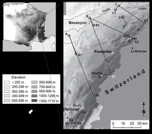
Sixteen temperature measurement sites under forest cover are distributed across the plateaus and mountains of the Jura (France). They are composed of pairs of stations located, one at the bottom of a topographic trough, the other at least 50 m higher in altitude. Three descriptors (station elevation, altitudinal difference (amplitude) between the two stations of each site, and topographical context) are used to explain how the frequency, intensity, and duration of inversions are spatially structured.
Depending on whether one considers: 1) tn (minimum temperature) or tx (maximum temperature), 2) frequency or intensity, the sign of the correlation values changes. This reflects the fact that not all inversions can be explained in the same way. Elevation moderately explains the three characters of the inversions. Amplitude mainly explains their frequency (R = -0.83 for daily minima [tn]) and their intensity (R = 0.62 for daily maxima [tx]). The magnitude of the topographic depressions where the low stations are located mainly explains the tn inversions while the magnitude of the eminences where the high stations are located mainly explains the tx inversions. Finally, a multiple regression where the explanatory variables correspond to the topographic descriptors makes it possible to model the three inversion indicators.
Keywords
temperature under forest cover, elevation, topography, inversion, Jura.
- extrait:
- lien_externe:
- kc_data:
- a:8:{i:0;s:0:"";s:4:"mode";s:0:"";s:3:"css";s:0:"";s:9:"max_width";s:0:"";s:7:"classes";s:0:"";s:9:"thumbnail";s:0:"";s:9:"collapsed";s:0:"";s:9:"optimized";s:0:"";}
- kc_raw_content:
- Topographic descriptors and thermal inversions amid the plateaus and mountains of the Jura (France)
Daniel JOLY et Yves RICHARD. Climatologie, vol. 15 (2018)
Sixteen temperature measurement sites under forest cover are distributed across the plateaus and mountains of the Jura (France). They are composed of pairs of stations located, one at the bottom of a topographic trough, the other at least 50 m higher in altitude. Three descriptors (station elevation, altitudinal difference (amplitude) between the two stations of each site, and topographical context) are used to explain how the frequency, intensity, and duration of inversions are spatially structured.
Depending on whether one considers: 1) tn (minimum temperature) or tx (maximum temperature), 2) frequency or intensity, the sign of the correlation values changes. This reflects the fact that not all inversions can be explained in the same way. Elevation moderately explains the three characters of the inversions. Amplitude mainly explains their frequency (R = -0.83 for daily minima [tn]) and their intensity (R = 0.62 for daily maxima [tx]). The magnitude of the topographic depressions where the low stations are located mainly explains the tn inversions while the magnitude of the eminences where the high stations are located mainly explains the tx inversions. Finally, a multiple regression where the explanatory variables correspond to the topographic descriptors makes it possible to model the three inversion indicators.
Keywordstemperature under forest cover, elevation, topography, inversion, Jura.