l’article du mois – janvier 2012
 Climatic gradients along the winward slopes of Mount Kenya and their implication for crop risks management. Part 1: Climate variability

Par P Camberlin, J Boyard-Micheau, N Philippon, C Baron, C Leclerc et C Mwongera
International Journal of Climatology, published on line. doi:10.1002/joc.3427
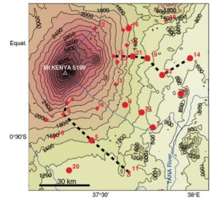
In tropical mountains, the way topographical gradients translate in terms of intra-seasonal and interannual climate variability (especially rainfall and evapotranspiration) is relatively unknown, yet it is an important issue for agriculture and food security. The eastern slopes of Mount Kenya, in East Africa, with their wide range of agroecological conditions, are appropriate to study these aspects. Daily (monthly) rainfall data from 11 (24) stations at different elevations and exposures are collected for the period 1961-2006. For the elevation belts suitable for farming and agro-pastoral activities, mostly below 2000 m, it is found that not all rainfall characteristics co-vary with altitude.
Four distinct behaviours are revealed. (i) Parameters which show a relatively regular increase / decrease with elevation. This is the case for the duration of the two rainy seasons found across the region, and the mean onset and cessation dates. (ii) Parameters which show a relatively uniform pattern throughout the region, with little differences both horizontally and vertically. This applies to the interannual variability of the October-December seasonal rains, which are quite homogeneously modulated by Indian Ocean sea-surface temperatures. (iii) Parameters markedly influenced by exposure. This applies to daily rainfall intensities, which peak along the southeast-facing slopes, whatever the altitude. The frequency of rainy days shows both a vertical gradient and some influence of exposure. (iv) Parameters which show very weak spatial coherence, or pronounced vertical discontinuities. This is obvious for the cessation date of the March-May rains, whose poorly organised interannual variability contrasts with that of the onset.
Variables involved in potential evapotranspiration (ET0) computation display either a strong (maximum temperature) or a weak (global radiation) vertical coherence, reflecting the existence / absence of an elevation control on the mean distribution of these variables. However, the interannual variations of global radiation have the strongest influence on those of ET0.
- extrait:
- lien_externe:
- kc_data:
- a:8:{i:0;s:0:"";s:4:"mode";s:0:"";s:3:"css";s:0:"";s:9:"max_width";s:0:"";s:7:"classes";s:0:"";s:9:"thumbnail";s:0:"";s:9:"collapsed";s:0:"";s:9:"optimized";s:0:"";}
- kc_raw_content:
- Climatic gradients along the winward slopes of Mount Kenya and their implication for crop risks management. Part 1: Climate variability
Par P Camberlin, J Boyard-Micheau, N Philippon, C Baron, C Leclerc et C MwongeraInternational Journal of Climatology, published on line. doi:10.1002/joc.3427
In tropical mountains, the way topographical gradients translate in terms of intra-seasonal and interannual climate variability (especially rainfall and evapotranspiration) is relatively unknown, yet it is an important issue for agriculture and food security. The eastern slopes of Mount Kenya, in East Africa, with their wide range of agroecological conditions, are appropriate to study these aspects. Daily (monthly) rainfall data from 11 (24) stations at different elevations and exposures are collected for the period 1961-2006. For the elevation belts suitable for farming and agro-pastoral activities, mostly below 2000 m, it is found that not all rainfall characteristics co-vary with altitude.
Four distinct behaviours are revealed. (i) Parameters which show a relatively regular increase / decrease with elevation. This is the case for the duration of the two rainy seasons found across the region, and the mean onset and cessation dates. (ii) Parameters which show a relatively uniform pattern throughout the region, with little differences both horizontally and vertically. This applies to the interannual variability of the October-December seasonal rains, which are quite homogeneously modulated by Indian Ocean sea-surface temperatures. (iii) Parameters markedly influenced by exposure. This applies to daily rainfall intensities, which peak along the southeast-facing slopes, whatever the altitude. The frequency of rainy days shows both a vertical gradient and some influence of exposure. (iv) Parameters which show very weak spatial coherence, or pronounced vertical discontinuities. This is obvious for the cessation date of the March-May rains, whose poorly organised interannual variability contrasts with that of the onset.
Variables involved in potential evapotranspiration (ET0) computation display either a strong (maximum temperature) or a weak (global radiation) vertical coherence, reflecting the existence / absence of an elevation control on the mean distribution of these variables. However, the interannual variations of global radiation have the strongest influence on those of ET0.